Ylihärmä
| Ylihärmä | ||
|---|---|---|
| Former municipality | ||
| Ylihärmän kunta | ||
|
Ylihärmä Church | ||
| ||
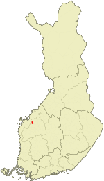 Location of Ylihärmä in Finland | ||
| Coordinates: 63°08.5′N 022°47.5′E / 63.1417°N 22.7917°ECoordinates: 63°08.5′N 022°47.5′E / 63.1417°N 22.7917°E | ||
| Country | Finland | |
| Region | Southern Ostrobothnia | |
| Sub-region | Härmänmaa sub-region | |
| Founded | 1868 | |
| Consolidated | 2009 | |
| Area[1] | ||
| • Total | 152.17 km2 (58.75 sq mi) | |
| • Land | 151.7 km2 (58.6 sq mi) | |
| • Water | 0.47 km2 (0.18 sq mi) | |
| Population (2008-12-31)[2] | ||
| • Total | 2,916 | |
| • Density | 19.22/km2 (49.8/sq mi) | |
| Population by age[3]> | ||
| • 0 to 14 | 18.1% | |
| • 15 to 64 | 59.8% | |
| • 65 or older | 22.1% | |
| Time zone | EET (UTC+2) | |
| • Summer (DST) | EEST (UTC+3) | |
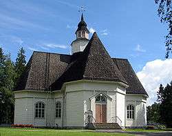

Ylihärmä is a former municipality of Finland. It was consolidated, together with Alahärmä and Kortesjärvi, to Kauhava on 1 January 2009.
It is located in the province of Western Finland and is part of the Southern Ostrobothnia region. The municipality had a population of 2,916 (as of 31 December 2008)[2] and covered a land area of 151.70 square kilometres (58.57 sq mi).[1] The population density was 19.22 inhabitants per square kilometre (49.8/sq mi).
The municipality was unilingually Finnish.
References
- 1 2 "Area by municipality as of 1 January 2008" (PDF) (in Finnish and Swedish). Land Survey of Finland. Retrieved 20 January 2011.
- 1 2 "Population by municipality as of 31 December 2008". Population Information System (in Finnish and Swedish). Population Register Center of Finland. Retrieved 20 January 2011.
- ↑ "Population according to age and gender by area as of 31 December 2007". Statistics Finland's PX-Web databases. Statistics Finland. Retrieved 1 January 2009.
External links
 Media related to Ylihärmä at Wikimedia Commons
| Municipalities |  | |
|---|---|---|
| Former municipalities | ||
This article is issued from Wikipedia - version of the 4/22/2015. The text is available under the Creative Commons Attribution/Share Alike but additional terms may apply for the media files.