Clifton, South Carolina
| Clifton | |
|---|---|
| CDP | |
  Clifton Location within the state of South Carolina | |
| Coordinates: 34°59′10″N 81°49′13″W / 34.98611°N 81.82028°WCoordinates: 34°59′10″N 81°49′13″W / 34.98611°N 81.82028°W | |
| Country | United States |
| State | South Carolina |
| County | Spartanburg |
| Area | |
| • Total | 1.137 sq mi (2.946 km2) |
| • Land | 1.073 sq mi (2.778 km2) |
| • Water | 0.065 sq mi (0.168 km2) |
| Population (2010) | |
| • Total | 541 |
| • Density | 480/sq mi (180/km2) |
| Time zone | Eastern (EST) (UTC-5) |
| • Summer (DST) | EDT (UTC-4) |
| ZIP codes | 29324 |
| FIPS code | 45083 |
Clifton is a Census-designated place located in Spartanburg County in the U.S. State of South Carolina.[1] According to the 2010 United States Census, the population was 541.[2]
Geography
Clifton is located at 34°59′10″N 81°49′13″W / 34.98611°N 81.82028°W (34.986051, -81.820395).[1] These coordinates place the CDP on the East side of the county, between the cities of Spartanburg and Cowpens.
According to the United States Census Bureau, the CDP has a total land area of 1.073 square miles (2.946 km²) and a total water area of 0.065 square miles (0.168 km²).[1]
References
- 1 2 3 "US Gazetteer files: 2010, 2000, and 1990". United States Census Bureau. 2011-02-12. Retrieved 2011-04-23.
- ↑ See "Archived copy". Archived from the original on 2013-09-11. Retrieved 2008-01-31. for population numbers and for municipality and CDP lists in the 2010 Census.
Municipalities and communities of Spartanburg County, South Carolina, United States | ||
|---|---|---|
| Cities | 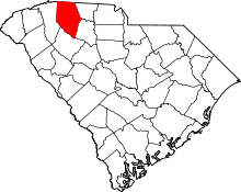 | |
| Towns | ||
| CDPs | ||
| Unincorporated communities | ||
| Ghost town | ||
| Footnotes | ‡This populated place also has portions in an adjacent county or counties | |
This article is issued from Wikipedia - version of the 11/26/2016. The text is available under the Creative Commons Attribution/Share Alike but additional terms may apply for the media files.