Las Plumas, California
Coordinates: 39°40′25″N 121°29′10″W / 39.67361°N 121.48611°W
| Las Plumas | |
|---|---|
| Former settlement | |
  Las Plumas Location in California | |
| Coordinates: 39°40′25″N 121°29′10″W / 39.67361°N 121.48611°W | |
| Country | United States |
| State | California |
| County | Butte County |
| Elevation[1] | 902 ft (275 m) |
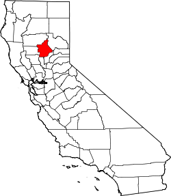
Las Plumas (Spanish for "The Feathers"; Latin: plūma "feather") is a former settlement in Butte County, California.
Geography
It was located 5 miles (8.0 km) west-northwest of Berry Creek on the North Fork of the Feather River,[2] at an elevation of 902 feet (275 m). It is now flooded by Lake Oroville.[3]
Climate
This region experiences warm (but not hot) and dry summers, with no average monthly temperatures above 71.6 °F. According to the Köppen Climate Classification system, Las Plumas has a warm-summer Mediterranean climate, abbreviated "Csb" on climate maps.[4]
History
A post office operated in Las Plumas from 1908 to 1967, with a closure from 1909 to 1912.[3] Its location on the Feather River gave the place its translated into Spanish name.[3] The town was located in the Feather River canyon, but was evacuated and flooded when Oroville Dam was built. Most former residents now live in nearby Oroville.
References
- ↑ U.S. Geological Survey Geographic Names Information System: Las Plumas, California
- ↑ Durham, David L. (1998). California's Geographic Names: A Gazetteer of Historic and Modern Names of the State. Clovis, Calif.: Word Dancer Press. p. 263. ISBN 1-884995-14-4.
- 1 2 3 Durham, David L. (1998). California's Geographic Names: A Gazetteer of Historic and Modern Names of the State. Clovis, Calif.: Word Dancer Press. p. 264. ISBN 1-884995-14-4.
- ↑ Climate Summary for Las Plumas, California