Sahebganj district
| Sahibganj district साहिबगंज जिला | |
|---|---|
| District of Jharkhand | |
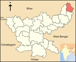 Location of Sahibganj district in Jharkhand | |
| Country | India |
| State | Jharkhand |
| Administrative division | Santhal Pargana Division |
| Headquarters | Sahibganj |
| Government | |
| • Lok Sabha constituencies | Rajmahal |
| • Assembly seats | 3 |
| Area | |
| • Total | 1,599 km2 (617 sq mi) |
| Demographics | |
| • Literacy | 53.73 per cent[1] |
| • Sex ratio | 948 |
| Website | Official website |
Sahibganj district (Hindi: साहिबगंज जिला) is one of the twenty-four districts of Jharkhand state, India, and Sahibganj is the administrative headquarters of this district.
Divisions
Sahibganj district is divided into two subdivions: Sahibganj subdivision and Rajmahal subdivision. It is further subdivided into nine Community development blocks:(Sahibganj subdivision) Sahibganj, Mandro, Borio, Barhait (Rajmahal subdivision) Taljhari, Rajmahal, Udhwa, Pathna and Barharwa.[2]
Economy
In 2006 the Ministry of Panchayati Raj named Sahibganj one of the country's 250 most backward districts (out of a total of 640).[3] It is one of the 24 districts in Jharkhand currently receiving funds from the Backward Regions Grant Fund Programme (BRGF).[3]
Demographics
According to the 2011 census Sahibganj district has a population of 1,150,038,[4] roughly equal to the nation of Timor-Leste[5] or the US state of Rhode Island.[6] This gives it a ranking of 407th in India (out of a total of 640).[4] The district has a population density of 719 inhabitants per square kilometre (1,860/sq mi).[4] Its population growth rate over the decade 2001-2011 was 23.96%.[4] Sahibganj has a sex ratio of 948 females for every 1000 males,[4] and a literacy rate of 53.73%.[4]
Administration
Blocks/Mandals
Sahibganj district consists of 09 Blocks. The following are the list of the Blocks in sahibganj district:
See also
References
- ↑ "District-specific Literates and Literacy Rates, 2011". Registrar General, India, Ministry of Home Affairs. Retrieved 2011-12-11.
- ↑ "District Profile". Census 2011. Sahibganj district administration. Retrieved 12 January 2016.
- 1 2 Ministry of Panchayati Raj (September 8, 2009). "A Note on the Backward Regions Grant Fund Programme" (PDF). National Institute of Rural Development. Retrieved September 27, 2011.
- 1 2 3 4 5 6 "District Census 2011". Census2011.co.in. 2011. Retrieved 2011-09-30.
- ↑ US Directorate of Intelligence. "Country Comparison:Population". Retrieved 2011-10-01.
Timor-Leste 1,177,834 July 2011 est.
- ↑ "2010 Resident Population Data". U. S. Census Bureau. Retrieved 2011-09-30.
Rhode Island 1,052,567
External links
 |
Bhagalpur district, Bihar | Katihar district, Bihar | | |
| Godda district |  |
Malda district, West Bengal | ||
| ||||
 | ||||
| Pakur district | Murshidabad district, West Bengal |

