Ellisdale, New Jersey
| Ellisdale, New Jersey | |
|---|---|
| Unincorporated community | |
|
Ellisdale from Province Line Road | |
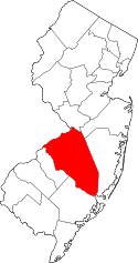
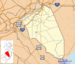  Ellisdale  Ellisdale  Ellisdale Location of Ellisdale in Burlington County (Inset: Location of county within the state of New Jersey) | |
| Coordinates: 40°07′54″N 74°35′03″W / 40.13167°N 74.58417°WCoordinates: 40°07′54″N 74°35′03″W / 40.13167°N 74.58417°W | |
| Country |
 United States United States |
| State |
 New Jersey New Jersey |
| County | Burlington and Monmouth |
| Township | North Hanover and Upper Freehold |
| Elevation[1] | 92 ft (28 m) |
| Time zone | Eastern (EST) (UTC-5) |
| • Summer (DST) | EDT (UTC-4) |
| GNIS feature ID | 876162[1] |

Ellisdale is an unincorporated community located along the border of North Hanover Township in Burlington County and Upper Freehold Township in Monmouth County, in New Jersey, United States.[2][3] The community is centered about the intersection of Province Line Road (through which the county line runs) and Hill Road (Upper Freehold) / Ellisdale-Crosswicks Road (North Hanover).[4] The Crosswicks Creek runs to the north of the settlement and the nearby Ellisdale Fossil Site takes its name from Ellisdale.
References
- 1 2 "Ellisdale". Geographic Names Information System. United States Geological Survey.
- ↑ Locality Search, State of New Jersey. Accessed March 16, 2015.
- ↑ Google (March 16, 2015). "Ellisdale, New Jersey" (Map). Google Maps. Google. Retrieved March 16, 2015.
- ↑ Google (June 14, 2015). "Aerial view of Ellisdale" (Map). Google Maps. Google. Retrieved June 14, 2015.
This article is issued from Wikipedia - version of the 6/8/2016. The text is available under the Creative Commons Attribution/Share Alike but additional terms may apply for the media files.