Dugandan, Queensland
| Dugandan Boonah, Queensland | |||||||||||||
|---|---|---|---|---|---|---|---|---|---|---|---|---|---|
 Town of Dugandan, circa 1907 | |||||||||||||
| Population | 395 (2011 census)[1] | ||||||||||||
| Postcode(s) | 4310 | ||||||||||||
| LGA(s) | Scenic Rim Region | ||||||||||||
| State electorate(s) | Beaudesert | ||||||||||||
| Federal Division(s) | Wright | ||||||||||||
| |||||||||||||
Dugandan is both a town and a locality in the Scenic Rim Region, Queensland, Australia.[2][3] In the 2011 census, Dugandan had a population of 395 people.[1]
History
The name Dugandan is believed to be an Aboriginal word dugai/tugai meaning mountain spur place.[2][3] Originally the name was used for a large pastoral run established in 1884, covering a much larger area than the current locality from Boonah to Mount Joyce. As a result, the name Dugandan was used for the present day town of Boonah until the 1880s when it acquired its present name.[4]
The Dugandan Provisional School which opened in 1878 was located in (present day) Boonah. This school was renamed Boonah State School in 1895.[5] Dugandan State School opened in (present day) Dugandan on 13 January 1917. It closed in 1966.[5]
By 1887 a sawmill was already established in Dugandan under the combined partnership of Josias Hancock and James Cossart.[6] Cossart's Mill became one of the major employers in the region and contributed significantly to the prosperity of Boonah and Dugandan into the twentieth century.[7]
Dugandan Post Office opened on 11 September 1887 (a receiving office had been open from 1881) and closed in 1929.[8]
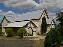
The Trinity Lutheran church opened on 23 April 1889.[9]
Heritage listings
Dugandan has the following heritage sites:
- 124 Boonah-Rathdowney Road: Dugandan Hotel [10]
- 237 Boonah-Rathdowney Road: Trinity Lutheran Church and Cemetery [10]
References
- 1 2 Australian Bureau of Statistics (31 October 2012). "Dugandan (SSC)". 2011 Census QuickStats. Retrieved 28 April 2014.
- 1 2 "Dugandan (town) (entry 10750)". Queensland Place Names. Queensland Government. Retrieved 28 April 2014.
- 1 2 "Dugandan (locality) (entry 45136)". Queensland Place Names. Queensland Government. Retrieved 28 April 2014.
- ↑ "Boonah". Queensland Places. Centre for the Government of Queensland, University of Queensland. Retrieved 28 April 2014.
- 1 2 "Agency ID8793, Dugandan State School". Queensland State Archives. Retrieved 28 April 2014.
- ↑ "Advertising". Queensland Times, Ipswich Herald And General Advertiser. XXVIII, (3960). Queensland, Australia. 29 October 1887. p. 5. Retrieved 3 October 2016 – via National Library of Australia.
- ↑ "Destructive Fire at Dugandan.". Queensland Times, Ipswich Herald And General Advertiser. XXXVII, (5600). Queensland, Australia. 1 June 1897. p. 5. Retrieved 3 October 2016 – via National Library of Australia.
- ↑ Premier Postal History. "Post Office List". Premier Postal Auctions. Retrieved 10 May 2014.
- ↑ "LUTHERAN CHURCH.". Queensland Times (Ipswich) (Qld. : 1909 - 1954). Ipswich) (Qld.: National Library of Australia. 17 April 1939. p. 6 Edition: DAILY. Retrieved 28 April 2014.
- 1 2 "Local Heritage Register" (PDF). Scenic Rim Regional Council. Retrieved 9 February 2015.
Coordinates: 28°01′17″S 152°40′40″E / 28.02139°S 152.67778°E
External links
- "Dugandan". Queensland Places. Centre for the Government of Queensland, University of Queensland.
- Dugandan Lutheran Cemetery