Teviotville, Queensland
| Teviotville Queensland | |||||||||||||
|---|---|---|---|---|---|---|---|---|---|---|---|---|---|
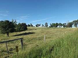 Farm along Teviotville Road, 2015 | |||||||||||||
  Teviotville | |||||||||||||
| Coordinates | 27°57′S 152°40′E / 27.950°S 152.667°ECoordinates: 27°57′S 152°40′E / 27.950°S 152.667°E | ||||||||||||
| Population | 273 (2011 census)[1] | ||||||||||||
| Postcode(s) | 4309 | ||||||||||||
| LGA(s) | Scenic Rim Region | ||||||||||||
| State electorate(s) | Beaudesert | ||||||||||||
| Federal Division(s) | Wright | ||||||||||||
| |||||||||||||
Teviotville is a locality in the Scenic Rim of South East Queensland, Australia. At the 2011 Australian Census the locality and surrounds recorded a population of 273.[1] The Teviotville Tree is located on private property in Teviotville. The tree was used in the filming of the 2010 film The Tree.
History
Teviotville was a stop along the closed Dugandan railway line. The name is derived from the name given to a railway stop by the Railway Department in 1887.[2] That was based on the name of the major watercourse in the area, Teviot Brook.[2] A school opened in the area in 1899. In 1981, the schools closed due to low enrolments.[3]
References
- 1 2 Australian Bureau of Statistics (31 October 2012). "Teviotville (Gazetted Locality)". 2011 Census QuickStats. Retrieved 15 April 2015.
- 1 2 "Nomenclature Of Queensland–276.". The Courier-Mail. Brisbane: National Library of Australia. 18 August 1936. p. 16. Retrieved 15 April 2015.
- ↑ "Teviotville State School". Queensland State Archives Agency ID10356. Queensland State Archives. Retrieved 15 April 2015.
External links
 Media related to Teviotville, Queensland at Wikimedia Commons
This article is issued from Wikipedia - version of the 5/16/2015. The text is available under the Creative Commons Attribution/Share Alike but additional terms may apply for the media files.