Tabooba, Queensland
| Tabooba Queensland | |||||||||||||
|---|---|---|---|---|---|---|---|---|---|---|---|---|---|
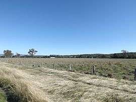 Paddocks along Christmas Creek Road, 2014 | |||||||||||||
  Tabooba | |||||||||||||
| Coordinates | 28°7′54″S 152°57′42″E / 28.13167°S 152.96167°ECoordinates: 28°7′54″S 152°57′42″E / 28.13167°S 152.96167°E | ||||||||||||
| Postcode(s) | 4285 | ||||||||||||
| LGA(s) | Scenic Rim Region | ||||||||||||
| State electorate(s) | Beaudesert | ||||||||||||
| Federal Division(s) | Wright | ||||||||||||
| |||||||||||||
Tabooba is a locality in the Scenic Rim Region of South East Queensland, Australia.[1] It is located at the confluence of Christmas Creek and Logan River. Logan River marks the western boundary. In the east the locality reaches elevations greater than 400 m above sea level, along Jinbroken Range.
Tramway
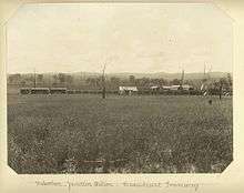
Tabooba Junction station, 1903
The Beaudesert Shire Tramway passed through Tabooba and opened in 1902.[2] The station was known as Tabooba Junction. Here the line split with one branch reaching Rathdowney and the other to Lamington.
References
- ↑ "Tabooba (entry 45189)". Queensland Place Names. Queensland Government. Retrieved 3 September 2014.
- ↑ "Beaudesert Shire Timeline". Scenic Rim Regional Council. Retrieved 3 September 2014.
This article is issued from Wikipedia - version of the 9/19/2014. The text is available under the Creative Commons Attribution/Share Alike but additional terms may apply for the media files.